Project Title: Monitoring and Assessment of Micro- and Macroplastic Pollution Levels in the Aquatic Environment of Lake Markakol
Implemented within the framework of grant funding No. AР14870595
Scientific Supervisor: PhD, Associate Professor A.S. Madibekov
Project Duration: 2022–2024
Client and Contract No.: Science Committee of the Ministry of Science and Higher Education of the Republic of Kazakhstan, Contract No. 255/30-22-24 dated October 18, 2022
The object of the study is Lake Markakol.
Project Objective: To monitor and assess the quality of the aquatic environment by studying the quantitative characteristics of micro- and macroplastic particles, heavy metals, persistent organic pollutants (polychlorinated biphenyls), as well as to update morphometric parameters in order to preserve the aquatic ecosystem of Lake Markakol.
Results:
In accordance with the work schedule, a comprehensive assessment of pollution in the aquatic environment (water and bottom sediments) and analysis of their spatial distribution in the “water–sediment” system were carried out. Field research and analysis were conducted based on direct observations. A bathymetric map of Lake Markakol was developed.
Systematic and comparative analytical methods, as well as computer technologies, were used in the processing of the collected data.
Field and laboratory research included the determination of microplastics in water and chemical-toxicological indicators in water and bottom sediment samples.
As part of our study, extensive fieldwork was conducted, including the collection of 334 water samples and the performance of 2,722 analyses. Furthermore, highly accurate bathymetric surveys were carried out, measuring 1,360,769 depth points in 2023 and 856,723 in 2024 across the lake's surface. These new morphometric data not only allowed the evaluation of spatial patterns of plastic pollution but also provided insights into the structure and characteristics of the lakebed. The high accuracy of these results makes them a reliable basis for developing effective strategies to reduce plastic pollution and preserve the ecosystem of Lake Markakol.
The analysis of plastic pollution in the lake’s aquatic ecosystem using Raman spectroscopy identified the presence of PP, PE, PS, PET, CuPc+PE polymers, primarily introduced by river inflows. The results indicate serious issues of microplastic pollution in the lake and its tributaries, where monofilament fishing nets, foam beads, plastic bags, bottles, wrappers, labels, and food packaging are predominant.
Chemical analysis revealed that the lake water is ultra-fresh, with mineralization up to 80.0 mg/dm³. Its total hardness is low, up to 1.20 mg-eq/dm³, both at the surface and bottom layers. According to O.A. Alekin’s classification, the water belongs to the hydrocarbonate class, sodium group, type I. Mineralization and ionic composition did not differ significantly between surface and bottom layers. Based on its physicochemical characteristics, the water belongs to oligotrophic lakes. However, elevated levels of dissolved oxygen and phosphates above the MAC for fisheries, as well as increased aquatic vegetation, suggest a shift toward mesotrophic or even eutrophic conditions, which are associated with high nutrient concentrations, excessive plant growth, and potential algal blooms.
Elevated nitrogen concentrations were recorded in the central and northern parts of the lake, where the Tikhushka, Topolevka, Zhirelka, and Matabai rivers flow in. Phosphate concentrations exceeded permissible levels, with surface water values ranging from 0.08 to 0.18 mg/dm³ and bottom water values from 0.03 to 2.15 mg/dm³ — averaging 0.10 mg/dm³ (2 MAC) and 0.36 mg/dm³ (7.2 MAC), respectively.
High phosphate concentrations indicate anthropogenic pollution and disturb biological equilibrium, promoting eutrophication and increasing biological productivity (i.e., algal blooms). Phosphate ions serve as a reliable indicator of anthropogenic pollution and are classified under hazard class III (based on organoleptic indicators), which is confirmed by the intensified eutrophication in Lake Markakol. These changes indicate possible anthropogenic impacts and disruptions to the biological equilibrium in the lake and its watershed.
Atomic absorption spectrophotometry revealed contamination from inflowing river waters: copper concentrations were 49.9 μg/dm³ and zinc 115.2 μg/dm³, while outflowing waters via the Kalzhyr River contained only 7.9 μg/dm³ of copper and 12.3 μg/dm³ of zinc. Elevated lead levels were recorded in the Urunkhayka (14.6 μg/dm³), Matabai (15.1 μg/dm³), Zhirelka (16.2 μg/dm³), and Tikhushka (17.2 μg/dm³) rivers. High cobalt concentrations were characteristic of all inflowing rivers.
The study confirmed PCB contamination of the lake’s water, its major tributaries, and bottom sediments. Different levels of toxic compound contamination were found across various parts of the lake and rivers, suggesting unequal impacts of pollution sources throughout the basin. A detailed study of PCB distribution in water and sediments revealed the most contaminated areas in the watershed.
Between 27 and 31 individual PCB congeners were detected in all studied water bodies and bottom sediments, including “marker” and dioxin-like congeners that are strictly regulated. According to researchers, the presence of as many as 30 forms of PCB congeners in natural environments indicates exposure to diverse sources of these toxicants.
Considering that PCBs are primarily transported atmospherically, and based on existing scientific findings, it is assumed that their presence in this protected area is a result of atmospheric deposition from highly polluted territories such as Ust-Kamenogorsk.
Analytical assessment of the spatiotemporal distribution of microplastics in the aquatic environment, risk assessment, and environmental impact
Microplastic pollution has become a pressing issue for aquatic ecosystems in Kazakhstan. Global and local literature highlights the wide distribution of microplastics in freshwater and marine systems, including lakes, rivers, and coastal zones. Despite limited research in Kazakhstan, significant levels of plastic pollution have been detected – including along the Caspian Sea, where debris poses a threat to endemic species like the Caspian seal (Pusa caspica).
One of the first large-scale studies on microplastic pollution in Kazakhstan was led by N. Salikova, focusing on landfills in Akmola region. Findings from these studies provide a basis for modeling microplastic behavior in soil and water, contributing to better understanding of its environmental impact. Similar studies are underway in other Central Asian countries – for example, screening of the Karadarya and Chirchik rivers in Uzbekistan revealed high concentrations of microplastic fibers likely originating from wastewater treatment plants.
Even remote water bodies, such as lakes in Siberia and mountainous regions, have shown considerable microplastic concentrations, with both natural and human sources contributing. Lake Markakol, located in a UNESCO biosphere reserve, was previously considered ecologically pristine. However, the study revealed significant microplastic contamination, particularly at river mouths such as Topolevka, Urunkhayka, and Matabai. These sites are now identified as accumulation zones requiring ongoing monitoring.
The study showed that while microplastics are retained within Lake Markakol, the Kalzhyr River, which flows out of the lake, contains minimal plastic – indicating the lake’s role as an environmental sink.
Such findings underscore the importance of national standards and regular monitoring to prevent pollution of water bodies.
Practical significance
The research outcomes are foundational for larger-scale projects aimed at microplastic monitoring and mitigation. Proposed measures include expanding collection, recycling, and waste management systems, introducing regulations to control plastic use, and promoting sustainable consumption and biodegradable alternatives. A comprehensive strategy like this could reduce anthropogenic pressure on Kazakhstan’s water resources and support the development of a green economy.
Thus, systematic study of plastic pollution serves as a basis for further research and the development of strategies to protect Kazakhstan’s aquatic ecosystems.
Mapping the spatial distribution of pollutants in the “water–sediment” system considering sedimentation processes; Development of a 3D model of the lake basin
To update morphometric characteristics, an integrated approach was applied to optimize data collection and analysis techniques. Modern instruments and technologies were used to enhance data accuracy and efficiency. Improved analytical methods and GIS technologies were applied to provide a more complete understanding of the lake’s morphology. As a result, new reference morphometric data for Lake Markakol were obtained, and a bathymetric map was developed in ArcGIS at a 1:100,000 scale.
All tasks were completed in full compliance with the calendar work plan. The results, including updated morphometric data and the identification of plastic pollution threats, are of great importance for the protection and management of this unique aquatic ecosystem.
Recommendations for maintaining the normative quality of the aquatic environment
The recommendations for preserving the ecological balance of Lake Markakol are based on a comprehensive analysis of water and sediment quality, as well as morphometric and hydrochemical parameters. Among the top priorities are enhanced control of illegal fishing and plastic waste management – particularly the removal of abandoned fishing nets, a significant source of microplastics.
It is essential to strengthen monitoring of heavy metals, especially in tributaries like the Yelovka River, where cadmium concentrations were found to exceed standards. Establishing a permanent water quality monitoring system with the involvement of local stakeholders would enable timely detection and elimination of environmental violations. Public awareness campaigns targeting residents and tourists about pollution risks and prevention of eutrophication are also crucial.
A ban on single-use plastic near the lake and encouragement of eco-friendly alternatives are recommended. Plastic pollution should be integrated into the national environmental monitoring program, with attention to microplastics in water and sediments. Regular cleanup events around the lake will also contribute to improving the ecological situation.
Key Publications
- Ismukhanova L.; Madibekov A.; Opp C.; Zhadi A.; Sultanbekova B.; Zhumatayev S. Status and Migration Activity of Lead, Cobalt and Nickel in Water and in Bottom Sediments of Lake Markakol, Kazakhstan. Appl. Sci. 2024, 14, 7487. https://doi.org/10.3390/app14177487
- Madibekov A.; Ismukhanova L.; Opp C.; Sultanbekova B.; Zhadi A.; Zhumatayev S.; Madibekova A. Plastic Pollution in the Aquatic Ecosystem of the High-Mountain Lake Markakol (Kazakhstan): First Observations and Conclusions. Appl. Sci. 2024, 14, 8460. https://doi.org/10.3390/app14188460
- Madibekov A.; Ismukhanova L.; Zhadi, A.; Sultanbekova B.; Zhumatayev S.; Madibekova A. Assessment of the Level of Pollution of the Aquatic Ecosystem of Lake Markakol with Mobile Forms of Copper and Zinc. Evergreen, 2024, 11, 1568-1579. https://doi.org/10.5109/7236812
- Musakulkyzy A., Madibekov A.S., Ismukhanova L.T., Bolatov K.M. Integral assessment of the water quality of the Markakol Lake in Kazakhstan part of Western Altai // News of the National Academy of Sciences of the Republic of Kazakhstan. Series of geology and technical sciences. – 2024. – № 3 (465). – Р. 119–132. https://doi.org/10.32014/2024.2518-170X.414 (http://www.geolog-technical.kz/assets/20244/9.119-132.pdf) CiteScore 1,8, SJR 0,509 Quartile Q3, Percentile 40.
- Madibekov A.S., Karimov A.M., Ismukhanova L.T., Zhadi А.О., Bolatov K.M. Markakol lake level regime as indicator of climate change // News of the National Academy of Sciences of the Republic of Kazakhstan, Series of Geology and Technical Sciences. – 2024. – № 3 (465). – Р. 82–94.
- Амиргалиев Н.А., Мадибеков А.С., Исмуханова Л.Т., Жәди А.Ө., Султанбекова Б. Полихлорированные бифенилы в водной экосистеме заповедного озера Маркаколь и впадающих в него рек. Гидрометеорология и экология. – 2024. № 2. – 81–94. https://doi.org/10.54668/2789-6323-2024-113-2-81-94
FIELDWORK PROGRAM
- Preparation for field trips:
- Before going to the field, thorough preparation is required, including:
- a) special instructions for sampling procedures;
- b) route planning in accordance with the sampling schedule;
- c) preparation of equipment and material lists;
- d) providing containers for sampling, washed according to standard procedures;
- e) supplying the laboratory with chemical reagents and standards;
- f) preparation of a checklist.
Rapidly changing parameters must be measured directly in the field (on-site). These include temperature, water transparency, pH, dissolved oxygen, etc.
Since field measurements involve the use of electrometers, calibration, and optical comparisons, personnel must be trained in the proper and accurate use of such equipment, following the prescribed procedures and instructions.
To obtain reliable analytical results and avoid contamination by dust, dirt, smoke, fumes, fingerprints, or grease during sampling and handling, all containers and equipment must be carefully cleaned according to the requirements of each type of analysis. Precise records should be kept of the sampling location and any specific environmental conditions at the time of sampling.
To aid station location referencing, sample tags must include station numbers or codes. Field journals should be prepared to document observations, including location, date, time, measurements taken, and any relevant conditions that could affect data interpretation, such as weather, presence of dead fish, algal blooms, and flow characteristics.
Journals must also include details on the analytical methods used and the calibration of instruments in the field. All field personnel must be trained to identify potential hazards and take necessary measures to minimize risk.
Water samples for determining ionic and salt composition are collected according to ST RK GOST R 51592-2003 "Water. General requirements for sampling." Sampling should be carried out in a clean, uncontaminated location. One-liter plastic bottles are used to collect water for ionic-salt composition and biogenic compound analysis (to be tested in the field laboratory). Plastic containers with tightly fitting caps must be sealed underwater to avoid changes in sample composition and contact with atmospheric air. Bottles should be filled evenly, without air mixing.
Note: Before collecting water samples, plastic and glass bottles must be rinsed with the water being sampled.
Samples delivered to the field laboratory will be analyzed for further chemical testing, in accordance with the following references:
- Alekin O.A., Fundamentals of Hydrochemistry. Leningrad: Gidrometeoizdat, 1970. – 442 pages;
- Standard Methods for Water Analysis, edited by Yu.Yu. Lurie. Moscow: Khimiya, 1973. – 376 pages.
The identification of macro- and microplastic particles will follow the methodology of M.B. Zobkova and E.E. Esyukova, which are among the first documents in Russian based on translated methodologies by Masura J., Baker J., Foster G., and Arthur C. (NOAA Marine Debris Research Program).
1.1 Measurement of Hydro-physical and Hydrochemical Parameters of Water
One of the main tasks of field research at the lake is the measurement of hydro-physical and hydrochemical parameters, as well as the sampling of water and bottom sediments for chemical and toxicological analysis.
The procedure includes determination of the following indicators:
- Physical properties: depth, transparency, temperature, pH;
- Chemical composition elements: carbon dioxide, dissolved oxygen, permanganate oxidizability, total hardness, ionic-salt composition, mineralization, biogenic compounds;
- Toxicological indicators: heavy metals (Cu, Zn, Pb, Cd, Co, Ni) and polychlorinated biphenyls (PCBs).
Sample preparation for toxicological analysis in the institute’s laboratory will include:
Water (surface and bottom layers):
- 250 ml of water filtered through white-ribbon paper filters for heavy metal analysis;
- 300 ml of water extracted for PCB analysis (50 ml of extract).
Bottom sediments and soil:
Each collected sample is spread on paper and air-dried. A 0.2 kg soil sample is ground with a pestle in a mortar and sieved through a 1 mm mesh. A subsample of about 5.0 g is taken from the air-dried sample. The determination of mobile metal forms follows method RD 52.18.289-90, using an acetate-ammonium buffer solution (pH 4.8), followed by atomic absorption analysis of the resulting solution.
1.2 Bathymetric Survey
The set of hydrographic fieldworks enabled the acquisition of data on the state, relief, and water surface to compile a bathymetric map and define hydrometric parameters.
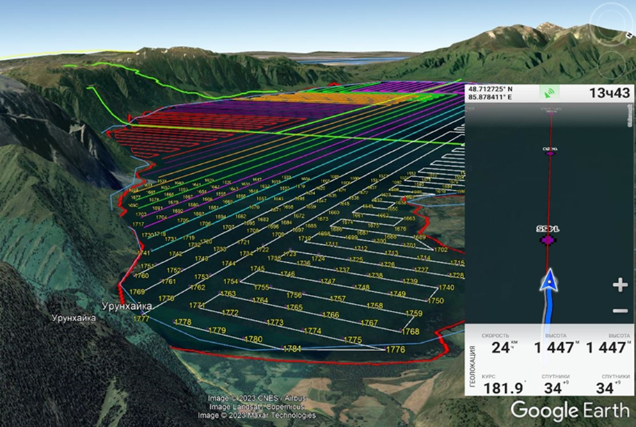
To facilitate navigation on the lake, previously prepared routes were uploaded as tracks to a mobile phone, which was used as a navigator. Navigation was carried out using the OfflineMaps application, with up-to-date satellite imagery preloaded. Navigation followed pre-prepared waypoints and tracks (Figure 1).
Bathymetric surveys aimed at creating a bathymetric map of the study lake will be conducted using a motorboat equipped with a Lowrance HDS-12 Live echo sounder-chartplotter. This device enables digital depth data recording onto an electronic storage medium and continuously registers the lake bottom profile along transects. The resulting bathymetric maps will be developed using licensed ArcMap software.
Depth measurements will be carried out along predefined transects, prepared in advance based on satellite imagery and other cartographic materials. These transects will cross the waterbody and be spaced at known intervals, strictly following the guidelines of SP RK 1.02-101-2014.
Depth measurements are classified according to several criteria:
- By the level of detail (survey precision);
- By the method of laying out transects;
- By the method of positioning along transects;
- By the method of depth measurement.
The primary method for depth measurement in engineering and hydrographic surveys is echo sounding with digital data recording to an electronic storage device and continuous bottom profile logging along the transects (currently using GPS receivers).
Transect orientation is determined based on the nature of depth distribution in the waterbody:
- For local surveys in elongated waterbodies – transects are laid perpendicular to the longitudinal axis;
- For full-coverage surveys of lakes, reservoirs, or large coastal marine areas with a circular shape – transects are laid perpendicular to the direction of the isobaths.
When transects are laid using shoreline reference points, alignment is made with contour points of the terrain, identified both in the field and on aerial imagery. This method does not require the development of geodetic survey networks (i.e., survey baselines), and the frequency of transects is determined based on underwater topography, which is visible on the imagery.
According to survey detail, depth measurements are divided into:
- Special,
- Detailed, and
- Simplified.
Each type of survey corresponds to a specific transect spacing, number of measured depths, and map scale. The main scales for compiling bathymetric plans and the corresponding transect frequency are determined based on the adopted survey classification and the complexity of the bottom relief.
Occupational health and safety regulations and precautionary measures for handling chemical reagents, equipment, measuring and heating devices under field conditions were followed in accordance with work safety and occupational safety instructions.
Scope of Work Carried Out During the Expeditionary Research
The conducted observations included the collection of water and bottom sediment samples for chemical and toxicological analysis:
- Physical properties: depth, transparency, temperature, pH;
- Elements of the chemical composition of water: carbon dioxide, dissolved oxygen, permanganate oxidizability, total hardness, ionic-salt composition, mineralization, and biogenic compounds;
- Toxicological indicators: heavy metals (Cu, Zn, Pb, Cd, Co, Ni) and polychlorinated biphenyls (PCBs).
Conclusion
A total of 154 samples of water and bottom sediments were delivered to the institute’s laboratory for chemical and toxicological analysis.
The set objectives and tasks were fully accomplished in accordance with the Fieldwork Program.
The results of both field and laboratory research are documented in the final report for 2024.