MINISTRY OF SCIENCE AND HIGHER EDUCATION
OF THE REPUBLIC OF KAZAKHSTAN
COMMITTEE OF SCIENCE
"APPROVED"
Authorized Person
JSC "Institute of Geography and Water Security",
Academician of the National Academy of Sciences of the Republic of Kazakhstan, Doctor of Geographical Sciences, Professor
_________________ A. Medeu
"____" _____________ 2020
DEVELOPMENT STRATEGY
of the Joint Stock Company
"Institute of Geography and Water Security"
for the period 2020-2030 and its
CONTENTS
INTRODUCTION 3
- CURRENT STATE ANALYSIS 4
- MISSION AND VISION 7
- STRATEGIC DIRECTIONS OF ACTIVITIES 8
3.1 Block 1. Geographical Research 8
Direction 1. Rational Natural Resource Management 8
Direction 2. Geoinformation Technologies 10
3.2 Block 2. Water Security of the Republic of Kazakhstan: Problems and Solutions 11
Direction 1. Water Security of Natural-Economic Systems of the Republic of Kazakhstan 11
Direction 2. Development of Theory and Methods for Assessing and Forecasting the Resources and Quality of Surface Waters in Kazakhstan 13
Direction 3. Economic Evaluation of Water Resources 15
3.3 Block 3. Natural Hazards 15
Direction 1. Hazardous Natural Processes 15
3.4 Block 4. Digitalization 17
Direction 1. Application and Implementation of Modern and Innovative Digital and Information Systems, Artificial Intelligence-Based Systems, Computer and Mathematical Modeling for Conducting Scientific Research in the Field of Geographical Studies and Water Security. 17
3.5 Block 5. Design and Design Survey Works 19
3.6 Block 6. Monitoring and Scientific Stations 19 - ORGANIZATIONAL STRUCTURE 20
- EFFECTIVE RESOURCE MANAGEMENT AND GROWTH OF THE INSTITUTE'S MATERIAL AND TECHNICAL BASE 21
- STAFFING 21
- ENSURING THE FINANCIAL STABILITY OF THE INSTITUTE 21
CONCLUSION 22
APPENDICES 23
INTRODUCTION
The Joint Stock Company "Institute of Geography and Water Security" (hereinafter referred to as the "Company") was established and registered in accordance with the current legislation of the Republic of Kazakhstan. The sole participant of the JSC is the Committee of Science of the Ministry of Education and Science of the Republic of Kazakhstan (hereinafter referred to as the "CNS MES RK").
This Development Strategy of the Company for 2020-2030 (hereinafter referred to as the "Strategy") aligns with the principles of development of the Republic of Kazakhstan, as outlined in such strategic documents as:
- The Address of the Head of State to the People of Kazakhstan dated December 14, 2012, "Kazakhstan Strategy-2050: A New Political Course of a Developed State";
- The Address of the President of the Republic of Kazakhstan Kassym-Jomart Tokayev to the People of Kazakhstan dated September 2, 2019, "Constructive Public Dialogue - The Foundation of Stability and Prosperity of Kazakhstan";
- The Address of the Head of State to the People of Kazakhstan dated January 17, 2014, "Kazakhstan's Path-2050: A Unified Goal, Unified Interests, Unified Future";
- The Strategic Plan for the Development of the Republic of Kazakhstan until 2025, approved by the Decree of the President of the Republic of Kazakhstan No. 636 dated February 15, 2018, with amendments from September 10, 2019;
- The Address of the Head of State Kassym-Jomart Tokayev to the People of Kazakhstan, "Kazakhstan in the New Reality: Time for Action" dated September 1, 2020;
- The Law of the Republic of Kazakhstan "On Science" dated February 18, 2011, No. 407-IV, with amendments as of May 21, 2022, No. 123-VII;
- On the Approval of the State Program for the Development of Education and Science of the Republic of Kazakhstan for 2020-2025;
- The Resolution of the Government of the Republic of Kazakhstan dated October 12, 2021, No. 726, On the Approval of the National Project "Quality Education: Educated Nation".
This document outlines the main strategic goals and tasks for the development of the Company for the period 2020-2030, which are closely linked with the Development Strategy of its sole participant, the Committee of Science of the Ministry of Education and Science of the Republic of Kazakhstan.
The implementation of the goals and objectives outlined in the Structure is based on ensuring effective interaction between all structural units of the Company. Upon the completion of the Strategy implementation, an assessment of the Company's activities will be conducted.
All program and planning documents of the Company will be developed in accordance with the provisions of this Strategy or brought into line with it.
1. ANALYSIS OF THE CURRENT STATE
Stages of the Institute's Transformation
- The Geography Sector of the Kazakh Branch of the USSR Academy of Sciences was established on November 3, 1938 (Resolution of the Council of People's Commissars of the Kazakh SSR No. 110/82).
- The Institute of Geography of the Academy of Sciences of the Kazakh SSR was created on the basis of the Geography Sector of the Academy of Sciences of the Kazakh SSR, in accordance with the Resolution of the Presidium of the Academy of Sciences of the Kazakh SSR No. 114 dated July 7, 1983.
- The State Enterprise "Institute of Geography" of the Ministry of Education and Science of the Republic of Kazakhstan was formed in accordance with the Government Resolution of the Republic of Kazakhstan dated October 13, 1999.
- The State Enterprise "Institute of Geography" of the Republican State Enterprise "Center for Geological and Geographical Research" of the Ministry of Education and Science of the Republic of Kazakhstan was created according to the decision of the Government of Kazakhstan under the Government Resolution of the Republic of Kazakhstan dated March 5, 2004, No. 280.
- The State Enterprise "Institute of Geography" of the Republican State Enterprise "Center for Earth Sciences, Metallurgy, and Enrichment" of the Committee of Science of the Ministry of Education and Science of the Republic of Kazakhstan was established in accordance with the Government Resolution of the Republic of Kazakhstan dated August 23, 2006, No. 800.
- The LLP "Institute of Geography" was established by order No. 134 of the JSC "Center for Earth Sciences, Metallurgy, and Enrichment" dated October 22, 2007.
- The JSC "Institute of Geography and Water Security" was transformed from the LLP "Institute of Geography" into a joint-stock company by the Government Resolution No. 753 dated October 11, 2019.
General Information
For 86 years since its establishment, the Institute of Geography of the Ministry of Education and Science of the Republic of Kazakhstan has been the leading research institution in the field of geography in Kazakhstan and the only specialized institute in the Central Asian region. The institute covers the main areas of geographical science: physical and socio-economic geography, hydrology, glaciology, and geoecology.
Currently, the Institute of Geography is involved in complex problems of the interaction between nature and society. The institute's research focuses on solving ecological problems and assessing the natural-resource potential of the republic's geosystems, with the development of geographical foundations for rational natural resource use.
In its early years, the research conducted by the Institute of Geography was primarily focused on the study of Kazakhstan's geography, including the description of the country, the distribution of its productive forces, and compiling data on climate and water resources. Over time, the research became more analytical and constructive, aimed not only at identifying the patterns of development of natural systems under intensive land use but also at solving urgent scientific and applied problems that were in demand by the state. Thus, over the course of its development, the institute has conducted fundamental research in the theory of geography, the assessment of Kazakhstan's natural-resource potential, and the scientific substantiation of programs for rational natural resource use and environmental protection.
Among the most significant programs of great socio-economic and environmental importance are: – The International Hydrological Program on the study of glacier mass and balance. – The interdisciplinary scientific and technical program for the rational use of water and land resources in the Ili-Balkhash region. – A series of international and national programs for environmental rehabilitation and socio-economic development of the destabilized Aral region, among others.
The results of research on snow depth and avalanche hazard in mountainous regions led to the development of original calculation methods and a series of maps of snow depth and avalanche hazards for the mountain ranges of Central Asia and Kazakhstan, as well as a series of special maps for the Atlas of Snow and Ice Resources of the World, including the Himalayas, Hindu Kush-Karakoram, Kunlun, Tibetan Plateau, Eastern (Chinese) Tian Shan, and Mongolian Altai.
As a result of interdisciplinary research, a package of measures was developed to intensify the use and protection of water and land resources in the Ili-Balkhash basin, including limiting irrigated land, reconstructing the Kapchagai Reservoir, and water management in the Ili River Delta. The implementation of these proposals helped prevent the catastrophic decline of Lake Balkhash in the 1970s and 1980s – a water body of special state significance.
Through international and national programs addressing the problems of the Aral Sea basin, the institute developed the conceptual foundations for an intergovernmental program to overcome the consequences of the Aral crisis and a series of proposals for projects on environmental rehabilitation and socio-economic recovery of Kazakhstan's part of the Aral Sea region, including improving the National Water Strategy in the Aral Sea Basin. These proposals were implemented in projects for river flow regulation in the lower reaches of the Syr Darya River, the restoration of deltaic lake systems, and the water management of rural communities in the depressed regions of Kazakhstan's Aral Sea basin.
The development of Kazakhstan's economic sectors in recent decades followed the path of extensive natural resource use, where the natural-resource potential of territories was primarily viewed as a means of achieving economic goals. The neglect of the environment's life-sustaining functions led to the destabilization of ecological conditions in some regions of Kazakhstan, resulting in reduced economic potential and increased social tension.
The main goals of the state policy in environmental protection and rational natural resource use, as outlined in the "Kazakhstan-2050 Strategy: A New Political Course for a Developed State" and the Strategic Plan for the Development of the Republic of Kazakhstan until 2025, the National Action Plan for the implementation of the Address of the Head of State to the People of Kazakhstan from January 17, 2014, "Kazakhstan's Path-2050: A Unified Goal, Unified Interests, Unified Future", and the Address of President Kassym-Jomart Tokayev to the People of Kazakhstan on September 2, 2019, "Constructive Public Dialogue – The Foundation of Stability and Prosperity of Kazakhstan," are the stabilization of the quality of the environment, the provision of a favorable habitat for humans, and the preservation of natural resources for future generations.
In light of the above, it is extremely important at present and in the foreseeable future to provide methodological, analytical, and informational support for state, regional, and local environmental protection programs and projects. The solution to these scientific problems falls within the framework of fundamental and applied research on the territorial organization of the "nature-society" system, which forms the essence of modern geography and geoecology.
Over 80 years of its activities, the Institute of Geography, which later transformed into the Joint Stock Company "Institute of Geography and Water Security," has developed the following key areas of geographical science to the international level: hydrology, glaciology, geomorphology, landscape science, and web technologies, and has participated in solving scientific and applied problems in all major national and international projects (the Aral Sea region, the Pre-Balkhash region, the Caspian region, the Semipalatinsk region, and more).
In addition to fulfilling a broad range of state fundamental research programs, the institute traditionally carries out a large volume of applied works of various kinds on a contractual basis.
The international authority of the Institute has grown. Its developments have been highly praised at international and national forums. Foreign specialists show scientific interest in the methodology, research methods, and results. The global level of scientific research is confirmed by joint work on programs and projects with companies and institutions from abroad, starting in 1992. The institute has participated in international projects funded by UNDP, UNESCO, NATO, the MacArthur Foundation, and various European Union funds (INTAS, Copernicus, and others).
During the years of independence, a number of large interdisciplinary scientific and technical programs were carried out, including:
Geographical direction:
- Republican Scientific and Technical Program "Scientific Foundations of the Target Program for the Socio-Economic Development of the Ecologically Destabilized Aral Region (RNTP-Aral)" 1991.
- PFI "Geographical Problems of Endorheic Basins of Kazakhstan" 1995-1996.
- PFI "Desertification and Natural Hazards of Kazakhstan" 2010-2012.
- PFI "Study of the Ecological State of Border Areas to Solve Food Security Problems (North Kazakhstan Region)" 2014.
- PFI "Theory and Methods of Optimizing the Geographical Environment and Rational Natural Resource Use" 1993-1994.
- PFI "Geographical Foundations for the Reconstruction of Destabilized Natural-Economic Systems of Kazakhstan" 1997-1999.
- PFI "Geographical Foundations for Sustainable Development of the Republic of Kazakhstan" 2009-2011.
- PFI "Geographical Foundations for Natural Resource Use in Mountainous and Plain Areas of Kazakhstan" 2012-2014.
- A series of scientific works on the atlas cartography of Kazakhstan: National Atlas of Kazakhstan (Vol. I, II, III), Atlas of Natural and Technogenic Hazards and Risks of Emergency Situations in Kazakhstan, Atlas of Mangistau Region, 2003-2010.
Water Security:
- PFI "Developing the Geographical Justification for the Sustainable Use of Natural Resource Potential and Surface Water of Transboundary Basins of Kazakhstan" 2000-2002.
- PFI "Geographical Justification for the Sustainable Development of Natural-Economic Systems of Kazakhstan" 2006-2008.
- PFI "Assessment of Resources and Forecasting the Use of Natural Waters of Kazakhstan under Anthropogenic and Climate-Induced Changes" 2009-2011.
- PFI "Geographical Foundations for Water Security in Kazakhstan" 2012-2014.
- PFI "Water Security of Kazakhstan – Geospatial Information System 'Water Resources of Kazakhstan and Their Use'" 2014-2016.
- PFI "Water Security of Kazakhstan – Strategy for Sustainable Water Supply" 2015-2017.
- PFI "Evolution of Glaciers and Glacial Systems in Transboundary Basins of Kazakhstan and Neighboring Central Asian Countries as the Basis for Assessing Current and Forecasting Regional Water Resources" 2015-2017.
- PFI "Transboundary River Basins of Kazakhstan and the People's Republic of China: Scientific and Applied Foundations for Sustainable Water Supply for the Population and Economy in the Context of Climate Change and Economic Activities up to 2050" 2018-2020.
- PFI "Development of Scientific and Applied Foundations for Water Security in Kazakhstan's Transboundary Aral-Syrdarya Basin until 2050" 2021-2022.
2.MISSION AND VISION
The mission of JSC "Geography and Water Security Institute" is to contribute to the creation of sustainable development in a strong Kazakhstan with a developed social sphere, efficient economy, and environmentally safe natural environment by presenting and implementing the results of scientific research in the field of geographical knowledge on key areas of state activity.
The main goal of JSC "Geography and Water Security Institute" is to conduct interdisciplinary research demanded by the state in the field of natural resource management and water security based on the development of comprehensive scientific and technical programs that integrate theoretical and experimental, fundamental and applied research to solve the problems of sustainable development of the Republic of Kazakhstan.
The vision of JSC "Geography and Water Security Institute" is to create a multifunctional, sustainably developing, and sought-after center in the republic with internationally recognized authority, combining scientific research, practical scientific activities, project work, and implementation in the field of rational natural resource management and ensuring the water security of the country to achieve the main goal.
3.STRATEGIC DIRECTIONS OF ACTIVITY
The scientific and applied structure of JSC "Geography and Water Security Institute" is presented in Figure 1.
Block 1. Geographic Research
Direction 1. Rational Natural Resource Management
Goal: To create a scientific, methodological, and analytical basis for managing the state of natural-economic systems (including natural, socio-economic, and tourist-recreational subsystems) as the foundation for environmentally safe and economically efficient natural resource management programs in Kazakhstan.
Systematic Task 1: Development of scientific and methodological support for the assessment of the state of natural-economic systems in the regions of Kazakhstan under economic and ecological challenges.
Target Indicators:
- Scientific and methodological support, analytical and cartographic databases, indicators of environmentally balanced natural resource management and sustainable development.
Key Activities:
- Development of scientific and methodological support for the sustainable functioning of natural-economic systems.
- Development of scientific foundations for environmentally balanced natural resource management in natural-economic systems to prevent negative anthropogenic processes and preserve ecological stability.
- Development of analytical and cartographic databases for the state and management of natural-economic systems based on field studies and the application of geographic information technologies.
Systematic Task 2: Eco-diagnostics, mapping of natural-economic systems, and assessment of the natural-resource potential of Kazakhstan's regions for effective natural resource management, ensuring ecological and economic stability.
Target Indicators:
- Qualitative and quantitative indicators of environmental status, natural-resource and economic potential indicators, evaluative cartographic models.
Key Activities:
- Assessment of the eco-geomorphological and landscape-ecological state of natural-economic systems based on field studies, remote sensing, and GIS technologies as the basis for effective natural resource management.
- Assessment of natural-resource and economic potential for effective natural resource management and the establishment of prospective directions for economic development.
- Creation of cartographic support for environmental, economic, and social aspects of sustainable natural resource management in natural-economic systems.
Systematic Task 3: Development of scientifically justified schemes for organizing natural resource management and its prospective directions as an instrument for the sustainable development of Kazakhstan's regions.
Target Indicators:
- Schemes for natural resource management, forecast of prospective directions, complex of scientifically substantiated recommendations and activities.
Key Activities:
- Development of landscape planning and functional zoning for multi-sector use purposes.
- Development of comprehensive natural resource management schemes, considering environmentally safe and economically effective management.
- Development of a set of scientific and applied recommendations, activities, and forecasting directions for the sustainable functioning of natural-economic systems.
Expected Results:
- Scientific-methodological and cartographic support for the sustainable development of natural-economic systems of the Republic of Kazakhstan, enabling the assessment of its landscape-ecological state, natural-resource and economic potential, and development prospects in the context of solving strategic tasks of the republic.
- Assessment of natural-resource and economic potential, ecological-geomorphological and landscape-ecological condition, evaluative cartographic models of natural-economic systems for effective resource use, ensuring ecological and economic stability.
- Scientifically substantiated scheme for natural resource management as a tool for the sustainable development of Kazakhstan’s regions, accounting for the preservation of ecological balance, landscape diversity, and natural-resource potential, allowing for the development of a complex of applied recommendations and activities to ensure environmentally and economically sustainable development of natural-economic systems in Kazakhstan and to establish prospective directions for socio-economic-ecological development and management of regions.
Direction 2. Geoinformation Technologies
Goal: Development of geoinformation products to create tools for displaying and cartographic analysis of research on natural-economic systems of Kazakhstan.
System Task 1: Creation of a geoinformation environment for storing, processing, and accessing geospatial data and applications for cartographic analysis.
Target Indicators:
- List and scientific-applied importance of the functional capabilities of the geoportal.
- Design and development of a corporate (Intranet) geoportal.
- Creation of tools for the geoportal to improve and expand functionality.
- Centralized database.
Key Activities:
- Development of a list of functional capabilities and requirements for the geoportal in direct interaction with all laboratories of the institute.
- Development of a technical assignment for the geoportal, justification of the selected architecture and development tools.
- Development of the geoportal, testing, interaction with other laboratories for clarification of functionality and obtaining feedback.
- Development of the database structure, geodata databases, and analytical data warehouses.
- Import of data from existing institute databases into the geoportal database.
System Task 2: Adaptation of the geoportal for publishing research results of the Institute in an open format.
Target Indicators:
- Implementation of a publicly accessible geoportal.
- Geospatial content (web cartographic services).
- Concept for opening research results of the Institute for public access.
Key Activities:
- Adaptation of the geoportal for operation as a publicly accessible internet service.
- Development of a concept and rules for opening research results for public access in collaboration with all laboratories of the Institute.
- Development of client and server parts of geoportal application software.
- Development, design, and publication of cartographic web services created based on open data, filling out their metadata.
System Task 3: Development of software solutions for automating the collection, processing, and analysis of digital data from open sources to increase the research resource potential of the Institute.
Target Indicators:
- Database of analytical information and retrospective data on climate, snow cover dynamics, and remote sensing (RS) data.
- Functionality for collecting and analyzing data from open sources.
Key Activities:
- Development of software solutions for loading and analytically processing climate data, snow cover dynamics, and remote sensing data.
- Expansion of functionality for analyzing data from open sources.
Block 2. Water Security of the Republic of Kazakhstan: Problems and Solutions
Goal: Scientific and applied support for water security as the foundation for the sustainable development of the Republic of Kazakhstan.
Direction 1. Water Security of Natural-Economic Systems of the Republic of Kazakhstan
System Task 1: Improvement of interstate water relations of the Republic of Kazakhstan with neighboring countries.
Target Indicators:
- Scientific-applied basis of interstate agreements on water division in transboundary basins between the Republic of Kazakhstan and neighboring countries (People's Republic of China, Russian Federation, Republic of Uzbekistan, Kyrgyz Republic).
Key Activities:
- Adaptation and introduction of fundamental provisions of international water law into the negotiation process between the Republic of Kazakhstan and neighboring countries regarding water division in transboundary river basins, considering Kazakhstan’s geographical location and the specifics of its national water supply system.
System Task 2: Development of the systemic water management infrastructure of the Republic of Kazakhstan in conditions of changing water resources potential.
Target Indicators:
- Increased hydrological reliability and reduced water management risks in water supply systems.
Key Activities:
- Modernization of the river runoff regulation and distribution system, including optimization of parameters and regimes of existing and prospective long-term regulation reservoirs, as well as inter-basin redistribution channels.
System Task 3: Optimization of water use in the sectors of the economy of the Republic of Kazakhstan through increased productivity of the water used.
Target Indicators:
- Increased efficiency of irrigation systems, reduced irrigation standards, increased crop yields in irrigated agriculture systems.
Key Activities:
- Water conservation in irrigated agriculture by increasing the productivity of water used based on conducting hydraulic, hydro-meliorative, and agro-technical activities.
System Task 4: Optimization of ecological non-productive water consumption in the natural hydrographic network.
Target Indicators:
- Rehabilitation of ecological and environmental-forming functions of river systems in the face of increasing anthropogenic pressure.
Key Activities:
- Regulation of ecological water consumption in the hydrographic network of river basins as a limitation on anthropogenic pressure on water resource systems.
System Task 5: Development and evaluation of alternative scenarios for the development of the National Water Management Complex of the Republic of Kazakhstan based on the development, adaptation, and implementation of modern methods, techniques, and technologies of mathematical and computer modeling of complex systems in water management planning and design practice.
Target Indicators:
- Increased operational efficiency, effectiveness, and accuracy of decisions made in water resource management tasks.
Key Activities:
- Development of a dynamic-stochastic modeling concept for complex water management systems, logical-mathematical description of the model, design and development of software-mathematical tools, conducting numerical experiments with recommendations for use in planning and designing water management systems and facilities.
System Task 6: Application of innovative technologies and methods based on artificial intelligence and neural networks for water management and forecasting tasks in natural-economic systems of the Republic of Kazakhstan.
Target Indicators:
- Evaluation of the effectiveness of using innovative technologies in water resource management and forecasting tasks with artificial intelligence and neural networks.
Direction 1. Development of Scientific and Applied Tools for Mathematical and Computer Modeling of Water Management Systems
Key Activities:
- Development and adaptation of information systems based on artificial intelligence and neural networks for forecasting and water resources management in the Republic of Kazakhstan.
- Design of software-mathematical tools for modeling the forecasting process and water resources management.
Expected Results:
- Creation of a tool for planning the development scenarios of the national water management complex of the Republic of Kazakhstan using modern information technologies to optimize and automate the resolution of strategic water resources management tasks.
- Development of prospective water supply scenarios for the Republic of Kazakhstan, evaluated according to water security criteria, in the context of expected climate-induced changes in the water resources potential of the country and increasing anthropogenic pressure on water resources.
- Development of advanced and innovative methods and technologies for forecasting and managing water resources in natural-economic systems of the Republic of Kazakhstan, incorporating information systems based on artificial intelligence and neural networks.
- Expansion of the methods and tools for mathematical and computer modeling of natural-economic systems.
Direction 2. Development of Theory and Methods for Evaluating and Forecasting the Resources and Quality of Surface Waters in Kazakhstan
Goal: Assessment and forecasting of surface water resources and quality in Kazakhstan, considering transboundary issues and climatic and anthropogenic changes.
System Task 1: Assessment and Forecasting of Water Resources in the Context of Regional Distribution Characteristics.
Target Indicators:
- Status of surface water resources in Kazakhstan: current and prospective, creation of a database on river runoff and lake resources by water management basins and administrative units, inventory and recommended cartographic packages.
Key Activities:
- Long-term hydrological forecasts by water management and administrative divisions of Kazakhstan.
- Solving tasks related to surface water resource management using modern mathematical and geoinformation modeling methods, considering regional distribution patterns and characteristics across Kazakhstan.
- Development of scenarios for rational use of transboundary surface water resources, taking into account the impact of climate change and economic activities in neighboring areas.
System Task 2: Study of the Regime and Quality of Surface Waters: Rivers, Streams, Lakes, and Reservoirs.
Target Indicators:
- Assessment of water balance components, creation of a database for hydrological and hydrochemical data of water bodies: retrospective and current status.
- Creation of digital passports for all water bodies.
Key Activities:
- Use of remote sensing methods, lasers, and isotope analysis to obtain hydrological characteristics.
- Research on water pollution with highly toxic contaminants.
- Research on atmospheric precipitation and the assessment of cumulative pollution in depositing media (soils, etc.).
- Assessment of the status and development of scenarios for expected surface water quality levels.
System Task 3: Development of Methods for Calculating and Forecasting Dangerous Hydrological Phenomena.
Target Indicators:
- Assessment of extreme hydrological phenomena hazards, creation of a database on extreme hydrological phenomena: floods, low water periods, and floods: retrospective, current, and projected future status.
Key Activities:
- Hydrological calculations to assess and forecast extreme hydrological phenomena (floods, low water periods, and floods).
- Research aimed at eliminating the risk of potential emergencies in water bodies.
Expected Results:
- Assessment of surface water resources in Kazakhstan: current and projected status, taking into account modern climatic and anthropogenic changes, in light of regional distribution patterns.
- Methods for studying the regime of surface waters, assessment of key elements of the water balance for rivers and lakes.
- Scenarios for the rational use of transboundary surface water resources, considering the impact of climate change and economic activities in neighboring areas.
- Assessment of the risk of extreme hydrological phenomena (floods, low water periods, and floods): retrospective, current, and projected future status.
- Current status and scenarios for expected changes in the water quality of Kazakhstan's water bodies, recommendations for maintaining normative water quality in the country's water basins.
- Pollution levels in water and biological resources in water bodies from persistent organic pollutants (POPs) in light of Kazakhstan’s obligations under the Stockholm Convention on POPs.
- Geoecological assessment of cumulative pollution levels in depositing media (soils, etc.) due to atmospheric precipitation.
- Characteristics of changes in the water quality of major transboundary basins of Kazakhstan under the expected reduction in transboundary inflows and climate change.
- Advanced and modern methods and criteria for assessing water quality.
- Global experience in stationary observations and the implementation of automated systems for water quality monitoring in river basins.
- Research aimed at preserving normative water quality under conditions of reduced water inflows from transboundary rivers, climate change, and the elimination of risks from potential emergencies related to water quality deterioration.
Direction 3. Economic Assessment of Water Resources
Goal: Economic assessment of the water resource potential of the Republic of Kazakhstan and the direction of its rational use in the context of sustainable development and the introduction of market mechanisms.
System Task 1: Study of the Principles and Methods for Economic Assessment of Water Resources in the Republic of Kazakhstan Using Market Mechanisms.
Target Indicators:
- Identification of new principles and methods for paid water use, significantly improving the market efficiency of water resource use in Kazakhstan.
Key Activities:
- Gathering data on the demand and supply volumes by year, the costs for ensuring water use, testing and implementation of a paid water use model.
System Task 2: Water Resource Potential of Kazakhstan in Modern Market Conditions and Directions for Rational Use in the Context of Sustainable Development of Natural-Economic Systems.
Target Indicators:
- Study, development, and modeling of scenarios for optimal water resource use in natural-economic systems to ensure socio-economic development in Kazakhstan. Principles and models for the optimal spatial structure of water use in Kazakhstan’s economy for effective implementation of the country's development strategy in an open economy.
Key Activities:
- Economic assessment and modeling of the development potential of territories and natural-economic complexes of the Republic of Kazakhstan to solve tasks for rational and economically efficient water use.
System Task 3: Scientific and Applied Foundations for Managing Economic Risks of Water Use in the Context of Changes in the Water Resource Potential of Kazakhstan.
Target Indicators:
- Assessment of water use risks in Kazakhstan by river basins, a map of economic risks for territories involved in agricultural turnover. Recommendations for the development and implementation of water use policies, agricultural development in Kazakhstan, considering global trends in climate change based on scientifically substantiated risk management approaches.
Key Activities:
- Study of the assessed territories, processing of natural and economic data, modeling optimal conditions for the functioning of water management systems in rural areas.
Block 3. Natural Hazards
Direction 1. Dangerous Natural Processes
Goal: Creation of a scientific-methodological and analytical base to ensure life safety, development of theoretical and methodological foundations for risk management.
System Task 1: Study of manifestations of dangerous natural processes using modern methods: ground-based georadar, ground-based laser scanner, unmanned aerial vehicles.
- Target Indicators:
Obtaining field data on the manifestations of dangerous natural processes necessary for risk assessment and modeling. - Key Activities:
- Training staff on the use of modern methods for observing natural hazards.
- Conducting fieldwork on studying the manifestations of dangerous processes.
System Task 2: Modeling dangerous natural phenomena based on real manifestations using digital terrain models.
- Target Indicators:
Obtaining calibrated models.- Results of modeling.
- Key Activities:
- Acquisition of licenses for model usage.
- Training employees on using models.
- Modeling dangerous natural processes.
System Task 3: Study of the spatial distribution of dangerous natural phenomena using remote sensing methods and GIS.
- Target Indicators:
Regularities of spatial distribution of dangerous natural phenomena. - Key Activities:
- Collecting archival data on the manifestations of dangerous processes.
- Conducting field studies on the distribution of dangerous natural phenomena.
System Task 4: Creation of databases and GIS for dangerous natural processes and phenomena.
- Target Indicators:
Databases and GIS for dangerous natural processes and phenomena. Regularities of spatial distribution of dangerous natural phenomena. - Key Activities:
- Collection of data on the manifestations of dangerous processes.
- Creation of databases and GIS for dangerous natural processes and phenomena.
System Task 5: Development of methods for assessing and mapping the hazards and risks of natural disasters, natural catastrophes, and changes in the natural environment.
- Target Indicators:
Methods for assessing and mapping hazards and risks of natural disasters, natural catastrophes, and changes in the natural environment. - Key Activities:
- Analysis of existing methods in Kazakhstan and abroad.
- Development of modern methods for assessing and mapping natural hazards and risks.
System Task 6: Preparation of hazard and risk maps for natural disasters, natural catastrophes, and changes in the natural environment in the Republic of Kazakhstan according to requests from the Ministry of Emergency Situations, akimats, and other interested organizations.
- Target Indicators:
Maps of hazards and risks of natural disasters, natural catastrophes, and changes in the natural environment. - Key Activities:
- Preparation of hazard and risk maps for natural disasters, natural catastrophes, and changes in the natural environment.
Expected Results:
- Regularities in the formation and spread of dangerous natural processes and phenomena.
- Calibrated mathematical models of dangerous natural phenomena based on field data.
- Databases and GIS for dangerous natural processes and phenomena.
- Methods for assessing and mapping the hazards and risks of natural disasters, natural catastrophes, and environmental changes.
- Hazard and risk maps for natural disasters, natural catastrophes, and environmental changes in the Republic of Kazakhstan.
Block 4. Digitalization
Goal: Design, development, support, and modernization of software, as well as the infrastructure of the institute, to create a more modern and powerful center that combines scientific research, scientific-practical, design, and implementation activities to enhance competitiveness in the market.
Direction 1. Application and implementation of modern and innovative digital, information systems, systems based on artificial intelligence, computer and mathematical modeling for conducting scientific research in the field of geographical studies and water security.
System Task 1: Development of the information system for JSC: Implementation of a project management system, electronic document management, systematization and increase of efficiency in scientific research, development of the IG and WB sphere on the Internet.
- Target Indicators:
- Electronic project management system "IG and WB" deployed within the institute’s intranet.
- Electronic document management, reporting control, and protocols of interaction between laboratories. Concept of the publication process, submission of articles, obtaining protective documents for conducted research work.
- Key Activities:
- Design, development, and implementation of an electronic project management system, including the analysis of existing solutions, collection of functional and non-functional requirements from the institute's employees as future users.
- Development of an electronic documentation system, improving reporting control for scientific research.
- Conducting research in prospective and innovative scientific areas.
- Creation of a concept for the scientific-methodological part, developing guides and internal documents to improve the efficiency and quality of scientific research, and creating training materials.
System Task 2: Application and implementation of modern and innovative digital, information systems, systems based on artificial intelligence, computer and mathematical modeling for conducting scientific research.
- Target Indicators:
- Use of mathematical and computer modeling for automation and improving the efficiency of scientific research.
- Evaluation of the implementation and effectiveness of innovative digital technologies for solving tasks in the current and prospective areas of JSC work.
- Use of software for automating the collection, storage, and processing of information.
- Key Activities:
- Conduct research on the potential use of computer and mathematical modeling to automate and improve the efficiency of scientific research.
- Evaluate the implementation and effectiveness of innovative digital technologies for solving tasks in the current and prospective areas of JSC work.
- Develop innovative methods and tools for solving water security, geographical studies, and GIS problems.
- Design and develop software and software-mathematical tools that allow automating the processes of collecting, storing, and processing information.
System Task 3: Creation of a coordination center for information security, mathematical and computer modeling, including design, development, support, and accounting of software and technical equipment created or used by JSC "IG and WB" employees. Systematization of the use of third-party software. Creation of an electronic register for software and technical equipment.
- Target Indicators:
- Coordination center for mathematical and computer modeling, software development, software-mathematical and applied tools with a centralized structure and adherence to information security principles.
- Unified electronic register of software used, including third-party software with paid content and usage requirements, ensuring compatibility of software versions used by JSC employees.
- Unified electronic register of hardware and technical equipment, computer network components of the institute, including provisions for conducting preventive maintenance of computing systems.
- A unified concept for purchasing computing machines and components, ensuring the selection of necessary computing machine characteristics for the needs of JSC "IG and WB."
- Modernized local network of the institute, domain controller, proxy server, and other components of the institute's computer infrastructure.
- Key Activities:
- Establishment of a coordination center for mathematical and computer modeling, software development, software-mathematical, and applied tools using a centralized structure and adhering to information security principles.
- Creation of an electronic register for software used, including third-party software with paid content and usage requirements, ensuring compatibility with the versions of software used by JSC employees.
- Creation of an electronic register for hardware and technical equipment, computer network components of the institute, with provisions for conducting preventive maintenance of computing systems.
- Development of a concept for purchasing computing machines and components to ensure the necessary specifications for JSC "IG and WB."
- Modernization and optimization of the institute's local network, domain controller, and associated systems, ensuring the use of up-to-date software versions and antivirus protection.
- Review of the need for a fully internal intranet, closed to external access.
Expected Results:
- Developed institute infrastructure using modern digital technologies in the form of an automated project management system, electronic document management, ensuring increased efficiency of scientific and applied research.
- A coordination center for mathematical and computer modeling, software development, software-mathematical, and applied tools, ensuring support for the information needs of all laboratories.
- Implementation and use of modern technologies to improve the quality of scientific research in key areas of development of JSC "IG and WB."
- A centralized electronic register for software and technical equipment, ensuring compatibility of software and hardware, and supporting infrastructure in an up-to-date state.
- An acceptable level of information security, including the development of a local computing network.
- A dedicated unit for managing and filling the company’s website, ensuring site promotion on the internet and maintaining up-to-date information.
Block 5. Design and Survey Works
The introduction of innovative technologies into the practice of designing natural-economic objects based on the methodology and technology of computer dynamic-stochastic modeling of the development tasks of natural-economic complexes in Kazakhstan, using digital systems based on "artificial intelligence" and neural networks technology for solving forecasting and optimization problems in natural resource management.
Block 6. Monitoring
Innovative development of monitoring systems for natural-economic complexes in the country by expanding the network of stationary points equipped with modern high-tech means for obtaining and processing information.
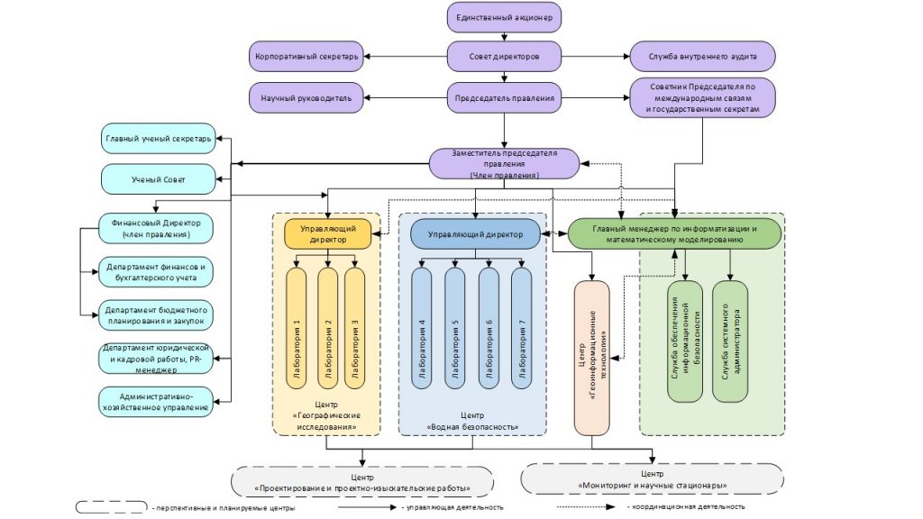
4. ORGANIZATIONAL STRUCTURE
JSC "Institute of Geography and Water Security"
- Effective Resource Management and Strengthening the Institute's Material and Technical Base
Development and improvement of the Institute's asset structure to implement and further utilize the results of scientific and/or scientific-technical activities in various sectors of the economy, social sphere, and ecology.
Modernization of the Research Infrastructure:
- Acquisition of the Institute's building with a total area of at least 5000 m²;
- Creation and equipping of new integrated research stations at Lake Alakol and the Ili River;
- Gradual equipping of laboratories with equipment intended for field and research work;
- Provision of expeditionary vehicles such as pickup trucks and one mobile hydrochemical and ecotoxicological laboratory.
A list of planned equipment acquisitions and station construction is provided in Appendices A and B of the Institute's Development Strategy.
- Human Resources
Building human resources capacity:
- Training highly qualified specialists in demand in the market of provided services according to the Development Strategy;
- Internship programs for specialists in neighboring and distant foreign countries.
- Ensuring the Institute's Financial Stability
Objectives:
- Ensuring growth of the Institute's consolidated revenues;
- Attracting targeted, grant funding from state and non-state sources;
- Attracting financial resources for research through participation in tenders for government and non-government organizations' contracts for the Institute's main research directions;
- Generating income from foreign funding sources, including through joint work with various organizations on the Institute's main research directions;
- Creating a mechanism for ensuring transparency of the Institute's financial and economic activities in compliance with the laws and regulations of the country;
- Ensuring the Institute's financial stability and profitability.
Conclusion
JSC "Institute of Geography and Water Security" will contribute to the effective integration of Kazakhstani science into the country's economy, market implementation of scientific achievements through the innovation process, and promote the scientific-technical and technological support of innovative industrialization and technological modernization in the republic in priority areas of the Society's activities.
The achievement of goals and tasks will be ensured through the implementation of development programs and ensuring the Institute's activities in the development and application of scientific and/or scientific-technical results in priority sectors of the economy. The approaches laid down in the Strategy will, in turn, improve the quality and relevance of research.
To implement the Strategy, the scientific-technical, financial, and informational resources of the LLP "Institute of Geography" will be fully utilized.
The achievement of key indicators and expected results will contribute to improving such global competitiveness index (GCI) indicators as "Quality of Research Institutes," "Scientific Collaboration between Universities and Industry," "Innovation Capacity," "Availability of Scientists and Engineers," "Access to Latest Technologies," "Company Expenditure on Research and Development," and "Scientific Infrastructure."
The Strategy is formed under the socio-economic conditions of the current date and may be adjusted in case of changes in external economic and political factors, changes in macroeconomic indicators of the country, or other significant circumstances.
CONTACT INFORMATION
Address: JSC "Institute of Geography and Water Security"
Almaty city, Almalinsky district, Seyfullin Avenue 458/1, Republic of Kazakhstan
Phone: +7(727) 291-81-29
Fax: +7(727) 291-81-02
E-mail: ingeo_2009@mail.ru