 |
Head of the Department – Dr. Amanzhol Kuderin, PhD
|
|
 |
Scientific Director of Fundamental and Applied Research – Assoc. Prof. Irina Skorintseva, Doctor of Geographical Sciences |
|
History of the Department . Department of Landscape Study and Problems of Nature Management started from the landscape group by the Sector of Geography of the Academy of Sciences of the Kazakh SSR in 1960 under the leadership of Professor Chupakhin Viktor, Doctor of Geographical Sciences. From 1976 till 2006, Head of the Department was a well-known scientist Professor Geldyyeva Galina, Doctor of Geographical Sciences, who was the founder of landscape school of Kazakhstan. From 2006 to 2024, the head of the laboratory was Assoc. Prof. Irina Skorintseva, Doctor of Geographical Sciences. Today, Head of the Department is Dr. Amanzhol Kuderin, PhD. Research works of employees of the department is aimed at the achievement of balanced territorial development including solution of problems of nature management by different types and kinds of anthropogenic impact to the landscapes.
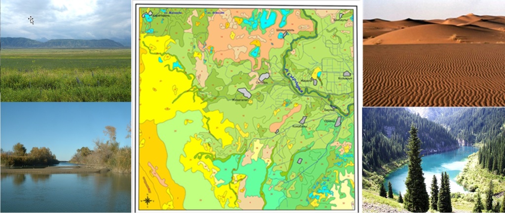
Landscapes of Kazakhstan
Main directions of researches:
Classification and systematization of landscapes of Kazakhstan;
- Principles and methods of different scaled landscape and landscape-ecological mapping;
- Principles and methods of assessment and mapping of sustainability of landscape-irrigational systems of arid zones of Kazakhstan;
- Methods of assessment and mapping of landscape, landscape-ecological condition of transboundary territories for sustainable nature management;
- Complex landscape-ecological and ecological-demographic researches directed to organization of sustainable natural-economic systems;
- Identification of criteria of landscape-ecological assessment of the territory of the Republic of Kazakhstan by different types of anthropogenic impacts;
- Applied and target landscape researches for the territorial-planning works, land cadastre, sustainable development of natural-economic systems, land use and land-utilization of the Republic of Kazakhstan.
Realized programs of fundamental and applied researches allowed to receive the following main results:
- Theory and methods of landscape assurance of regional schemes for desertification control;
- Theory and methods of landscape assurance of regional schemes for rational land use and land-utilization, land-cadastre works;
- Theory and principally new methodical approaches to assessment and mapping of social-demographic processes taking into account landscape-ecological factors;
- Methods and criteria of landscape-ecological assessment and mapping of zones of irrigated arable farming of destabilized intercontinental basins of Kazakhstan;
- Methods of assessment of impact of agricultural production to the landscapes;
- Methods and criteria of landscape-ecological assessment and mapping of boundary territories of Kazakhstan by different types of economic;
- methodology of analysis and assessment of landscape-ecological condition of natural-economic systems of Kazakhstan;
- systematization and classification of species diversity of landscapes was carried out, the structure and content of legends for landscape maps were developed;
- geoinformation support of pasture lands of Kazakhstan with development of GIS-mapping models (fodder resources, livestock load on pastures, pasture watering, breed zoning and accounting of reserve lands) to ensure sustainable pasture cattle breeding in Kazakhstan;
- schemes of organization of sustainable nature management of the border territory of Kazakhstan in the context of transboundary cooperation;
- theoretical-methodological and applied provisions of landscape planning for balanced land use in desert natural-agricultural systems of Kazakhstan;
- Maps series of regions of Kazakhstan: inventory, assessment, indicative, prognostic, recommended, scientific-reference, multipurpose functional and other.
Staff. At present time in the department are working 8 employees:
Dr. Amanzhol Kuderin, PhD – Head of the Department
Assoc. Prof. Irina Skorintseva, Doctor of Geographical Sciences – Chief Researcher
Prof. Zhumakhan Mustafayev, Doctor of Technical Sciences – Chief Researcher
Tatyana Bassova, Candidate of Biological Sciences – Chief Researcher
Dr. Gulnar Aldazhanova, PhD – Senior Researcher
Askhat Toletayev – Researcher
Aidos Omarov – Researcher
Batyr Kerimkulov – Lead Engineer
Specialists of the Department are high qualified and have large experience in the area of landscape study, ecology, and environment protection, cartography, solution of problems of nature use. They posses international certificates proving their qualification in application of GIS-technologies and earth remote sensing.
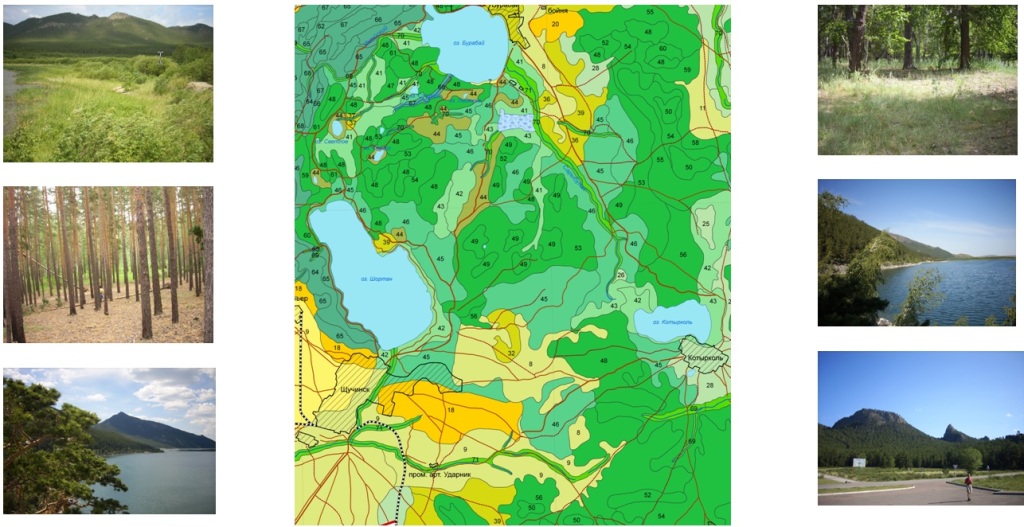
Fragment of landscape map of Shchuchinsk-Borovskaya health-resort zone
Hirsch Index (H-index) of Laboratory Staff
According to Scopus
https://www.scopus.com/pages/home#basic
Prof. Zhumakhan Mustafayev, Doctor of Technical Sciences – H-index: 5
Assoc. Prof. Irina Skorintseva, Doctor of Geographical Sciences – H-index: 4
Tatyana Bassova, Candidate of Biological Sciences – H-index: 3
Dr. Amanzhol Kuderin, PhD – H-index: 2
Dr. Gulnar Aldazhanova, PhD – H-index: 2
Askhat Toletayev – H-index: 2
Aidos Omarov – H-index: 1
Prospect of development. During last years, new prospective directions, having big importance for the development of new branches of Kazakhstan's economy, are developing in the department:
- Assessment of landscape inhomogeneity of regions in the Republic of Kazakhstan for rational land use and land planning;
- development of a methodology for assessment and mapping of the natural resource potential of the Republic of Kazakhstan;
- development of landscape planning of the Republic of Kazakhstan for the purposes of sustainable development;
- development of fractional landscape-agroecological zoning of the Republic of Kazakhstan;
- Study and mapping of landscape of suburb zones of urban agglomerations of the Republic of Kazakhstan for architectural-planning and project developments;
- Working out landscape assurance of works for creation of Land cadastre of the Republic of Kazakhstan;
- Development of a methodology for assessing the efficiency of the use of landscapes of the Republic of Kazakhstan for agricultural nature management, etc.
Publications. During last years, 7 monographs and more than 170 scientific articles were published due to the obtained results of researches in the department. Main of them are:
Monographs:
- Skorinceva I.B., Basova T.A., Mustafaev ZH.S., Kalashnikov A.A., Ckhaj M.B. Vodnaya bezopasnost' Respubliki Kazahstan: transgranichnyj Aralo-Syrdariinskij bassejn. T.VI: Vodopotreblenie naseleniem i otraslyami ekonomiki. – Almaty, 2024. – 204 p. ISBN 978-601-81100-4-7 (monography).
- Mustafaev ZH.S., Tursynbaev N.A., Kirejcheva L.B. Obosnovanie ekosistemnyh uslug pri obustrojstve rechnyh bassejnov (na primere reki Talas). – LAP LAMBERT Academic Publishing, 2022. – 127 p. ISBN: 978-620-5-50983-8 (monography).
- Skorinceva I.B., Basova T.A., Kalashnikov A.A., Krylova V.S., Mustafaev ZH.S. Vodnaya bezopasnost' Respubliki Kazahstan: transgranichnye bassejny rek Ile i Ertis. T.VI: Vodopotreblenie naseleniem i otraslyami ekonomiki. – Almaty, 2021. – 212 p. ISBN 978-601-80873-1-8 (monography).
- Landshaftno-ekologicheskie problemy prirodopol'zovaniya prigranichnyh territorij Respubliki Kazahstan. Almaty, 2011. - 236 p. (monografiya).
- Landshaftnoe obespechenie skhemy bor'by s opustynivaniem doliny reki Syrdar'ya. Almaty: Arkas, 2004. - 235 p. (monography).
In rating Journals included in the Scopus database:
- Tokbergenova A., Skorintseva I., Ryskeldiyeva A., Kaliyeva D., Salmurzauly R., & Mussagaliyeva, A. Assessment of Anthropogenic Disturbances of Landscapes: West Kazakhstan Region // Sustainability, – 2025. – Т. 17. – №. 2. – С. 573. https://doi.org/10.3390/su17020573 (Scopus: CiteScore 6.8 / SJR 0.672 / SNIP 1.086, Q1, 88-процентиль)
- Umirzakov S., Mustafayev Z., Tokhetova L., Baimanov Z., Akylbayev K., & Koldasova L. Modeling the Process of Crop Yield Management in Hydroagro-Landscape Saline Soils // Sustainability. – 2025. – Т. 17. – №. 9. – С. 4214. https://doi.org/10.3390/su17094214 (Scopus: CiteScore 6.8 / SJR 0.672 / SNIP 1.086, Q1, 88-процентиль)
- Toletayev A., Mustafayev, Z., Skorintseva I., Bassova T., & Omarov, A. Assessment of agroclimatic resources in agricultural landscapes of the Turkestan region of the Republic of Kazakhstan // Journal of Water and Land Development. – 2024. – С. 76-87-76-87. https://doi.org/10.24425/jwld.2024.151555 (Scopus: CiteScore 2.1 / SJR 0.282 / SNIP 0.541, Q3, 51-процентиль)
- Mustafayev Zh., Skorintseva I., Toletayev, A., Kuderin A., & Omarov A. Assessment of soil resources of agricultural landscapes in Turkestan region of the Republic of Kazakhstan based on agrochemical indexes. Open Geosciences. – 2024. – V. 16. – №. 1. – №. https://doi.org/10.1515/geo-2022-0652 (Scopus: CiteScore 3.1 / SJR 0.401 / SNIP 0.676, Q2, 60-процентиль)
- Mustafayev Zh., Skorintseva I., Toletayev, A., Aldazhanova G., & Kuderin A. Comprehensive assessment of water supply of the Turkestan region for the development of economic sectors and recreational tourism. GeoJournal of Tourism and Geosites. – 2024. – Т. 52. – №. 1. – С. 20-29. https://doi.org/10.30892/gtg.52102-1179 (Scopus: CiteScore 3.0 / SJR 0.332 / SNIP 0.962, Q3, 71-процентиль).
- Mustafayev Zh., Medeu A., Skorintseva I., Bassova T., & Aldazhanova G. Improvement of the Methodology for the assessment of the agro-resource potential of agricultural landscapes // Sustainability. – 2024. – Т. 16. – №. 1. – p. 419. https://doi.org/10.3390/su16010419 (Scopus: CiteScore 5.8 / SJR 0.664 / SNIP 1.198, Q1, 87-процентиль)
- Mustafayev Zh., Toletayev A., Skorintseva I., & Aldazhanova G. Assessment of Natural Moisture Availability of Turkestan Region of the Republic of Kazakhstan // Indonesian Journal of Geography. – 2023. – Т. 55. – №. 2. https://doi.org/10.22146/IJG.79703 (Scopus: CiteScore 1.3 / SJR 0.244 / SNIP 0.553, Q3, 35-процентиль)
- Mustafayev Zh. Skorintseva I., Toletayev A., Bassova T., & Aldazhanova G. Assessment of climate change in natural areas of the Turkestan region of the Republic of Kazakhstan for the purposes of sustainable agricultural and recreational nature management // Geo Journal of Tourism and Geosites. – 2023. – Т. 46. – №. 1. – С. 70-77 https://doi.org/10.30892/gtg.46108-1002 (Scopus: CiteScore 3.9 / SJR 0.323 / SNIP 0.699, Q3, 71-процентиль).
- Aldazhanova G., Beissenova A., Skorintseva I., Mustafayev Z., & Aliaskarov D. Assessment of land resources of the Zhambyl region as the basis of recreation development and food security of the Republic of Kazakhstan // Geo Journal of Tourism and Geosites. – 2022. – Т. 44. – №. 4. – С. 1183-1189. https://doi.org/10.30892/gtg.44401-933 (Scopus: CiteScore 3.9 / SJR 0.323 / SNIP 0.699, Q3, 67-процентиль).
- Mustafayev Zh., Kozykeeva А., Tursynbayev N., & Kireicheva L. Applied model of environmental services-development of ecological and economic drainage system of transboundary river basins (on the example of the Talas river basin) // News of the National Academy of Sciences of the Republic of Kazakhstan, Series of Geology and Technical Sciences. – 2021. – Т. 5. – №. 449. – С. 77-83. https://doi.org/10.32014/2021.2518-170X.101 (Scopus: CiteScore 1.8 / SJR 0.378 / SNIP 0.524, Q3, 43-процентиль)
- Medeu A.R., Skorinseva I.B., BasovaT.A. Water Supply to agriculture of Kazakhstan in the context of food security. Water resources of Central Asia and their use. Materials International Scientific-Practical Conference devoted to the summing-up of the «Water for Life» decade declared by the United Nations Almary, Kazakhstan, September 22-24, 2016 Volume 3. Алматы, 2016 – С. 202-211
- I. Skorintseva, Phd student A. Kuderin, Phd T. Basova, Phd V. Krylova. Landscape and ecological bases of food security in the republic of Kazakhstan // 16th International multidisciplinary scientific geoconference & EXPO SGEM. Book 5. Ecology, Economics, Education and Legislation // Conference Proceedings, 2016. - Albena, Bulgaria, 2016. - p. 521-528. (Impact Factor in SCOPUS is - 5 and the hi-index in ISI Web of Science (Thomson Reuters) is 6, which has increased with the listings of SGEM 2015 volumes).
- T. Basova, Phd student M. Khusnitdinova, Prof. G. Geldyeva, Prof. I. Skorintseva Anthropogenic disturbance of landscapes in the border area of Kazakhstan and Kyrgyzstan //16th International multidisciplinary scientific geoconference & EXPO SGEM. Book 5. Ecology, Economics, Education and Legislation // Conference Proceedings, 2016. - Albena, Bulgaria, 2016. – p. 45-52. (Impact Factor in SCOPUS is - 5 and the hi-index in ISI Web of Science (Thomson Reuters) is 6, which has increased with the listings of SGEM 2015 volumes)
In publications recommended by the Science and Higher Education Quality Assurance Committee (MSHE of RK):
- Mustafaev Zh.S, Kozykeeva A.T., Shugajyp U., Abdeshev K.B., Tursynbaev N.A. Analiz i ocenka tendencii izmeneniya gidrologicheskogo rezhima rek v vodosbore bassejna reki Nura // Gidrometeorologiya i ekologiya. – 2025. – №. 1. – S. 8-23 https://doi.org/10.54668/2789-6323-2025-116-1-8-23
- Popov N. V., Ranova S. U., Kamalbekova A. N., Aldabergen Ұ. R., & Skorinceva I. B. Analiticheskij obzor issledovanij proryvnyh glyacial'nyh selej v Kazahstane // Geografiya i vodnye resursy. – 2025. – №. 1. – S. 125-139. https://doi.org/10.55764/2957-9856/2025-1-125-139.12
- Egemberdieva K. B., Valeev A. G., Yushina Yu. A., & Skorinceva I. B. Ocenka rekreacionnoj nagruzki na turistskie marshruty i beregovye linii ozer GNPP «Burabaj» // Geografiya i vodnye resursy. – 2025. – №. 1. – s. 140-152. https://doi.org/10.55764/2957-9856/2025-1-140-152.13
- Mustafaev Zh., Adil'bektegi G., Mustafaev K., Abdeshev K., Saspugaeva G., Tursynbaev N.(2025). Modelirovanie elementov vodnogo balansa bassejna reki Sarysu na osnove dannyh gidrologicheskih i klimaticheskih nablyudenij. Vestnik ENU imeni L.N. Gumileva. Seriya: Himiya. Geografiya. Ekologiya, 150(1),129-151. https://doi.org/10.32523/2616-6771-2025-150-1-129-151
- Mustafaev Zh.S., Skorinceva I.B., Omarov A.N., & Tuletaev A.B. Ocenka agrobiologicheskih resursov landshaftov sel'skohozyajstvennogo ispol'zovaniya Turkestanskoj oblasti Respubliki Kazahstan v usloviyah izmenyayushchegosya klimata // Gidrometeorologiya i ekologiya. – 2024. – №. 2. – S. 113-127. https://doi.org/10.54668/2789-6323-2024-113-2-113-127
- Mustafaev Zh. S. Metody opredeleniya radiacionnogo balansa pochvennogo i rastitel'nogo pokrova sel'skohozyajstvennyh ugodij // Gidrometeorologiya i ekologiya. – 2024. – №. 2 (113). – S. 25-33. https://doi.org/10.54668/2789-6323-2024-113-2-25-33
- Mustafayev Z. S., Kozykeyeva A. T., Abdeshev K. B., & Tursynbaev N. A. Spatio-temporary climate variability and their manifestations in the watershed of the Assa-Talas river basin // Journal of Geography & Environmental Management. – 2024. – T. 74. – №. 3. https://doi.org/10.26577/JGEM.2024.v74.i3-05
- Mustafaev Zh. S., Kozykeeva A. T., Tastemirova B. E., & Ryskulbekova L. M. Ocenka antropogennoj nagruzki na vodosbor bassejna reki Tobyl ot istochnikov zagryazneniya s matematicheskim modelirovaniem kachestva poverhnostnyh vod // Gidrometeorologiya i ekologiya. – 2024. – №. 3 (114). – S. 100-113. https://doi.org/10.54668/2789-6323-2024-114-3-100-113
- Tokbergenova A. A., Basova T. A., Skorinceva I. B., & Ryskel'dieva, A. M. Ocenka sovremennoj landshaftnoj struktury Zapadno-Kazahstanskogo regiona // Geografiya i vodnye resursy. – 2024. – №. 3. – S. 84-95. https://doi.org/10.55764/2957-9856/2024-3-84-95.28
- Mustafaev Zh., Kuderin A., Omarov A., & Tuletaev A. Normirovanie vodopotrebleniya sel'skohozyajstvennyh ugodij i kul'tur s uchetom prostranstvenno-vremennoj izmenchivosti gidrometeorologicheskih faktorov // Geografiya i vodnye resursy. – 2024. – №. 2. – S. 3-14. https://doi.org/10.55764/2957-9856/2024-2-3-14.8
- Mustafayev Z., Tuletayev A., Kuderin A. Assessment of thermal and natural moisture provision in territory of Turkestan region of the republic of Kazakhstan in changing climate conditions // Journal of Geography & Environmental Management. – 2023. – T. 68. – №. 1. https://doi.org/10.55764/2957-9856/2024-2-3-14.8
- Aldazhanova G.B., Beisenova A.S. Assessment of environmental pollution of water and land resources of the territory of the Zhambyl region // Nuchno-tekhnicheskij i proizvodstvennyj gornyj zhurnal Kazahstana. – Almaty, 2019. – s. 39-40
- Aldazhanova G.B., Kuderin A.B. Ocenka zemel'nyh resursov Zhambylskoj oblasti dlya celej sel'skohozyajstvennogo osvoeniya // Voprosy geografii i ekologii – №2 – Almaty, 2019 - s.45-53
- Krylova V.S., Skorinceva I.B., Basova T.A. Metodicheskie osnovy ocenki i kartografirovaniya stepeni degradacii zemel' sel'skohozyajstvennogo osvoeniya Zhambylskoj oblasti // Voprosy geografii i geoekologii. - № 3, iyul'-sentyabr' 2018 g. – Almaty, 2018. - S. 119-127.
- Kuderin A.A., Skorinceva I.B., Basova T.A., Krylova V.S. Landshaftnoe planirovanie Zhanakorgano-Shielijskogo massiva orosheniya Kyzylordinskoj oblasti // Voprosy geografii i geoekologii. - № 3, iyul'-sentyabr' 2018 g. – Almaty, 2018. - S. 45-55.
Materials of international conferences of the CIS and non-CIS countries:
- Tuletaev A.B., Basova T.A., Omarov A.N. Ocenka ustojchivosti landshaftov Turkestanskoj oblasti k sel'skohozyajstvennomu vozdejstviyu // Materialy mezhdunarodnoj nauchno-prakticheskoj konferencii «Antropogennoe landshaftovedenie: metody issledovaniya, modernizaciya i ustojchivoe razvitie». – Samarkand, 17-18 maya 2024 g. – S. 158-161
- Krylova V., Skorinceva I., Basova T., Aldazhanova G. Ocenka degradacii zemel' sel'skohozyajstvennogo osvoeniya Zhambylskoj oblasti Respubliki Kazahstan // Mezhdunarodnaya nauchno-prakticheskaya konferenciya: Ekologicheskie problemy i ustojchivoe razvitie regionov i gorodov Respubliki Kazahstan. MGU im. Lomonosova (Kaz. filial). Nur-Sultan, – 2021. – S. 69-79.
- Bassova T., Aldazhanova G., Krylova V., & Skorintseva I. Evaluation of the natural resource potential of Zhambyl region as the framework for the development of agricultural production // 20th International Multidisciplinary Scientific GeoConference SGEM 2020. – 2020. – S. 323-330. https://doi.org/10.5593/sgem2020/5.1/s20.041
- Bassova T., Aldazhanova G., Skorintseva I., & Krylova V. Modern condition and tendencies of changing of the irrigated lands of the Zhambyl region of Kazakhstan // International Multidisciplinary Scientific GeoConference: SGEM. – 2019. – T. 19. – №. 5.1. – S. 469-476.


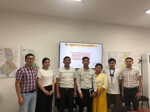
- Field researches. Many field researches on different landscape-ecological problems of the Republic of Kazakhstan were conducted by the employees of department. Field researches were concentrated on the study of the issues of formation and functioning landscapes of Kazakhstan. The priority in field researches is the study of spatial-temporal changes of landscapes under impact of anthropogenous factors of influence, study of sustainability of natural-economic systems, monitoring and mapping of modern condition of landscape of Kazakhstan. On the base of field researches, there was developed structure and content of legends to landscape maps of the republic and its regions, main landscape-ecological problems of the regions of Kazakhstan were revealed.